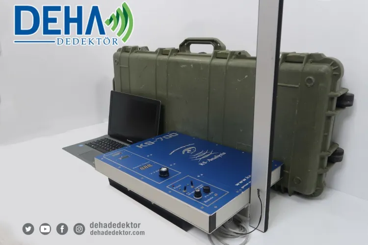
Ks 700 Underground Imaging System (Second Hand)
Free Shipping
Free shipping on orders over 500 TRY
24/7 Support
Support service between 08:30 - 22:00
Expert Training and Field Support
We provide expert training and field support service.
Description
KS-700 Underground Imaging System is a professional underground observation and analysis device that combines advanced radar and electromagnetic scanning technologies. It offers layered visualization of metal targets as well as iceboxes, cavities, tunnels, water lines, cables and other underground structures. It is a powerful underground imaging system designed to perform fast, reliable and detailed scanning in the field.
Advanced Underground Imaging Technology
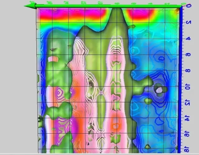
- Radar Based Scanning:Graphical 2D and 3D imaging of underground layers
- Electromagnetic Detection: Detecting metal, cable, pipe and structural anomalies
- Depth Analysis: Separating different soil layers according to their depth
- High-Resolution Display: Showing layer details clearly
Multiple Scanning Modes
- 2D Imaging: Analyzing underground layers on a horizontal plane
- 3D Visualization:Presenting depth and location information as a three-dimensional visual map
- Metal Detector Mode: Precisely detects metal targets
- Depth Layer Selection: Ability to scan at different depth levels
- Live Scan: Real-time monitoring of field data
User-Friendly Design and Controls
- Clear and easy-to-read screen interface
- Intuitive control with easy-to-use panel
- Advanced analysis with PC/Tablet connection support
- Possibility to save data and review it later
- Portable and field-oriented ergonomic design
Technical Specifications
- Scanning Technology: Radar + Electromagnetic
- Imaging: 2D and 3D underground layer imaging
- Display: Clear user interface (Tablet/PC compatible)
- Data Logging:Storing and analyzing field data
- Battery: Rechargeable battery for long field work
- Weight: Light and portable system
- Controls: Easy menu and button interface
Usage Areas
- Structural target detection such as cavities, caves and tunnels
- Location of metal lines, pipes and cables
- Localization of water lines and infrastructure elements
- Archaeological field analyzes and geophysical surveys
- Geological research and ground investigations
- Treasure search teams and advanced field work
Frequently Asked Questions (FAQ)
It is an advanced underground scanning and imaging system that combines radar and electromagnetic detection technology.
It analyzes metal lines, cables, pipes, cavities, tunnels, graves and other structural anomalies as visual layers.
While radar shows the ground layers 2D/3D visually; It detects electromagnetic, metallic targets precisely. Both together provide more detailed analysis.
While 2D offers simple scans; 3D visualizes the depth and location information of the target in more detail, which provides an advantage in excavation planning.
Yes; field data is recorded and enables subsequent analysis and graphical reporting.
The combination of radar and electromagnetic system provides more balanced performance in mineralized soils.
It is suitable for geophysical engineers, archaeologists, treasure hunting teams and advanced field researchers.
No; It is a system that is easy to learn and use thanks to its user-friendly interface and easy control panel.
KS-700 Underground Imaging System is a comprehensive underground analysis solution combining radar and electromagnetic technologies. It provides clear and detailed results in field studies with its advanced visualization capacity.
Installment Options
Related Products
Discover similar and complementary products selected for you.
Fast Shipping
All detector models are shipped with fast and secure cargo.
Precise Search
Advanced technology finds precious metals hidden deep underground.
High Quality
Professional quality, durable and long-lasting devices.
Easy to Use
Easy to use for both beginners and professionals.