

MALA Ground Penetrating Radar Systems
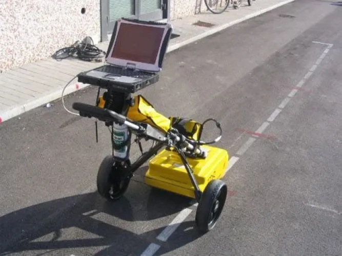
MALA RAMAC ground penetrating radar and imaging
The Mala Ramac listing is the product available in this MALA category. RAMAC is a family name; the control unit, antenna and acquisition equipment in the offered system must be identified separately. Do not infer a particular frequency, application or accessory from the family name alone. Suitability depends on the actual configuration supplied.
Ground penetrating radar investigates responses associated with changes in electromagnetic properties beneath the surface. Its output is not a direct photograph of an underground object. System characteristics, ground conditions and collection geometry all contribute to interpretation. A MALA RAMAC assessment should therefore consider the complete measurement chain, rather than only the appearance of a finished image.
MALA RAMAC antenna and control-unit compatibility
A RAMAC quotation should identify the antenna model, control-unit version and connecting components. Equipment produced by the same brand in different periods may not be directly interchangeable. A manual for a newer MALA unit should not be assumed to describe older RAMAC hardware. Matching manufacturer documentation to the actual labels helps resolve setup and compatibility questions correctly.
Antenna frequency should be considered with the required detail and site conditions. In general, higher-frequency arrangements can help resolve smaller features while penetration conditions differ. This relationship is not a fixed depth table. Conductivity, moisture, clay content and the properties of the feature being investigated can all influence the result.
Investigating a small, shallow infrastructure feature and examining a larger ground variation may lead to different antenna choices. Asking only for the deepest option before defining the task can overlook the necessary detail. Learn which antenna and site conditions produced a demonstration record. An image from another configuration should not be treated as a guaranteed result from the offered system.
| System component | Information to confirm | Effect on the work |
|---|---|---|
| Antenna | Model, frequency and condition | Required detail and survey scope |
| Control unit | Version and antenna compatibility | A functioning collection chain |
| Distance triggering | Wheel or other acquisition method | Consistency of horizontal position |
| Software | Installation, licence and file format | Review and retention of records |
Distance and line planning for MALA radar surveys
The horizontal axis of a radar profile depends on the collection method. In configurations using a distance wheel, its measurement and contact with the surface matter. Slipping, crossing obstacles or incorrect calibration can complicate the relationship between the record and the real position. Establish the triggering method used by the offered system and follow the relevant manufacturer checks.
For an area survey, plan line origins, spacing and direction in advance. Parallel profiles and crossing check lines can provide different views. However, placing files together without recording their actual positions is insufficient. Include fixed references, starting points and obstacles on the field sketch so that the data can later be related to the surveyed surface.
When a distinct response appears along a profile, note its position and consider a measurement from another direction where appropriate. A hyperbolic shape or strong reflection does not conclusively identify an object type. Geometry, surrounding materials and system characteristics must be considered together. Another view helps reveal the limits of an interpretation based on a single line.
Name files during collection rather than relying on memory at the end of a long session. An area identifier, line number and direction can provide a useful structure. Save a repeated line as a new file instead of overwriting the first. Preserving both records helps investigate whether a difference relates to movement, settings or the actual collection conditions.
Depth and image interpretation in MALA RAMAC data
Converting recorded travel time into depth requires an assumption or assessment of propagation velocity. The same time value may correspond to different depths in different materials. Establish how the displayed depth axis was calculated. A numerical depth should not be treated as independent of the assumptions used to produce it.
Processing can change how clearly a record is displayed. If gain, background processing or colour settings are applied, document them with the result. Retain the original data alongside the processed view. A later interpretation can then return to the source rather than depending only on a screenshot. The formats the software can open and export belong in the purchase assessment.
Surface and surrounding conditions also matter. Nearby structures, above-ground metal and changes in the surface can influence a record. Not every response should automatically be assigned to an underground target. In a complex area, reviewing the original profiles together with the sketch and field notes is more informative than interpreting an isolated coloured section.
Keep interpretation statements separate from direct observations in any report. For example, describe the position and continuity of a response before proposing what may have caused it. This makes the reasoning easier for another reviewer to assess. It also allows a later investigation to revise the interpretation without losing the original description of the recorded feature.
MALA RAMAC ground radar prices and delivery contents
Assess a MALA RAMAC price together with the control unit, antenna, software, power equipment, connections and any distance-measurement arrangement. Compare the current product-card amount with the written delivery list. An offer using another antenna or control unit should not be treated as the same system. If the package scope is unclear, the reason for a price difference remains unclear as well.
Maintenance condition and computer compatibility deserve attention for equipment from different production periods. A new profile collected with the actual system, saved and opened in the review software provides a useful demonstration. Cables, connectors, antenna wear surfaces and transport-exposed components can be inspected externally. Any required technical assessment should be performed by a suitable service provider or experienced specialist familiar with the equipment.
Clarify software licensing, installation access and any support scope during quotation. Do not assume identical terms for every RAMAC package. Opening a file on the intended computer is more meaningful than viewing an application screenshot. Being able to read and preserve the records over time is also part of the system's practical value.
Choosing a suitable MALA imaging configuration
The appropriate RAMAC configuration depends on the scale of the investigation and the needs of the person reviewing the data. Define the required detail, accessible surface and expected output first. Then assess whether the antenna, control unit and software serve that objective together. A single depth claim or brand name cannot select a configuration for every application.
The main underground imaging systems page provides other measurement approaches. You can also examine the KS Analysis ground radar category when researching ground radar options, while checking each system against its own technical documentation. For MALA RAMAC, the final practical reference is a sample record created with the offered hardware and reviewed in your intended environment. That workflow makes package scope and learning requirements tangible.
Frequently Asked Questions (FAQ)
Does the RAMAC name define antenna frequency?
No. Confirm the exact antenna and control-unit models in the offer.
Does MALA RAMAC reach the same depth in every ground condition?
No. Ground properties, configuration and the investigated feature affect the result.
Why can displayed depth depend on an assumption?
Converting travel time to depth uses propagation velocity, which depends on the material and its assessment.
Why check the distance wheel?
It can affect the relation between the record and actual distance. Follow the relevant calibration and contact checks.
Is analysis software included in the RAMAC price?
Confirm the delivery list, licence and installation scope for the specific offer.